The Story of Eelgrass in the Cowichan Estuary
While cleaning up old photo archives the other day I came across the following images showing extensive eelgrass fields located between the Westcan Terminal and the northern shoreline of Cowichan Bay. The photos were taken in the summer of 1979. These eelgrass meadows still existed until the mid-1980s when I first noticed bare patches of exposed soil appearing in the formerly dense eelgrass fields. This trend continued until no eelgrass was left to the north of the Westcan Terminal as shown by the results of CERCA's habitat mapping of the estuary. The mapping involved extensive ground-truthing and geo-referencing micro-habitats that had been identified on our high-resolution drone imagery of the estuary in 2017. Ground-truthing covered all of the inter-tidal flats including the most important ecotone where subtidal habitat meets the intertidal zone of the estuary.
I vividly and fondly recall our frequent crab gathering outings in the estuary during the first years of settling at the northern shore of the estuary in the mid-70s. What a sight and what an experience it was snorkeling in the summer above the sun-flooded eel grass fields where crabs were most abundant. Slowly floating across the lush eel grass softly swaying in the current at high tide, with crabs zig-zagging through the eelgrass across the sandy sea floor trying to escape our gloved hands is an experience not to forget! We never came home without our bag limit.
With the disappearance of eelgrass in the northern section of the estuary, salmon smolts and hundreds of other creatures depending on this critical habitat during their life cycle have disappeared or barely survive in sub-optimum habitat along the estuary's shoreline. Even the once-abundant starfish (see photo below) have disappeared for still unknown reasons.

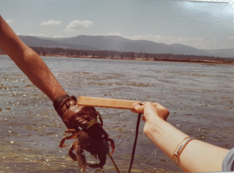
Seen in the background of the photo are log booms anchored to the dolphins along the deep water edge of the Cowichan Estuary.
Although there may be other factors contributing to the disappearance of eelgrass from estuaries in BC, one of the key causes, especially for estuaries of the East Coast of Vancouver Island, irrefutably are decades of estuary use for log boom storage, log transport, and irresponsible dredging. The Cowichan Estuary is no exception. More than a century of log sorting, log boom storage, and grounding out log booms along the edge of the inter-tidal area depositing tons of woody debris burying eelgrass and scaring the sea bed may well be the main culprit of eelgrass disappearance here and in other estuaries.
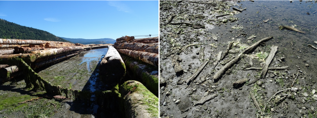

This is how the eelgrass beds of the estuary may have looked like before log booms appeared in the Bay.
Eelgrass meadows are recognized as the "Cradle of Life" for good reason. Eelgrass forms the base of a highly productive marine food web, providing food and shelter to all the creatures (and more) illustrated by the interpretative sign placed along our self-guided nature trail in the middle of the Cowichan estuary, along the "dock road" as shown below:
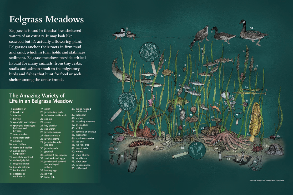
Apart from providing forage and shelter for young fish and invertebrates, food for migratory waterfowl, and spawning surfaces for species such as the Pacific herring, eelgrass meadows trap sediments, helping to stabilize the substrate, reducing the force of wave energy, and effectively helping to prevent coastal erosion. Furthermore, eelgrass meadows are amongst the most important carbon sinks of all ecosystems; they improve water quality by filtering contaminated runoff and providing many other goods and services.
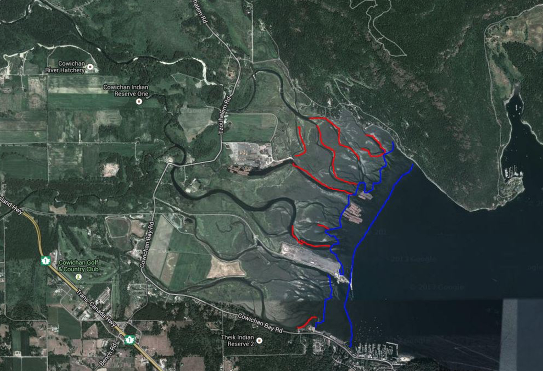
The area outlined in blue on the Google image below shows the prime growing area of eelgrass in the Cowichan Estuary where patches of eelgrass still existed until the early 1980s. The red lines indicate inter-tidal drainage channels where eelgrass was still found until the late 1970s. This also includes part of the Cowichan North Fork channel before it was dredged by Doman Industries in 1979 to transport log booms to its Mill pond, now operated by Western Forest Products Limited.
The area demarcated by the blue line unfortunately has been used for log storage for the past 100 years as witnessed by the placement of the dolphins along the deep water drop off.
Concerns about the damage by grounding out log booms at low tide scarring the surface of the inter-tidal area and smothering eelgrass meadows vital to salmon smolts, the DFO initiated a detailed study of the estuary in the late 1970s which eventually resulted in the elaboration of the Cowichan Estuary Environmental Management Plan CEEMP) that was ratified by Order in Council and placed under the management authority of BC's Ministry of Environment in 1987. As part of the agreement the total area leased to Forestry Companies for log boom storage, log sorting and transport in Cowichan Bay was dramatically reduced. At current, approximately 25 ha log storage remain under a 16 years Licence of Occupation by Western Forest Products Limited (see area covered by anchored booms on the Google image below).
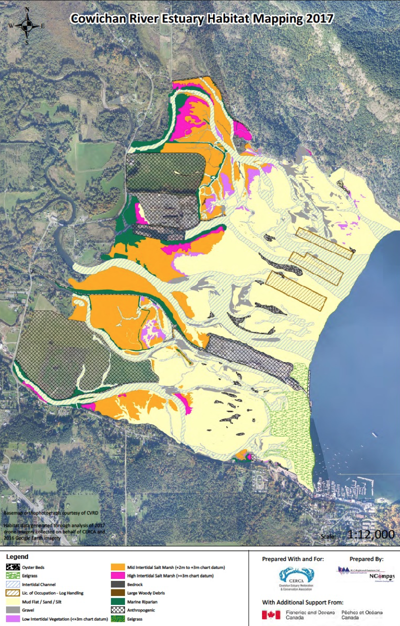
CERCA's 2017 Cowichan Estuary Habitat Map shows the only two eelgrass meadows left located to the south of the Westcan Terminal (see area hatched in green), and one patch adjacent to the north of the Terminal hugging the Government dock. The latter was the only area set aside for wildlife conservation in the estuary by the CEEMP.
The eelgrass meadow located in the lower intertidal zone of the southern section of the estuary happens to coincide with Lease area 103103. This Lease, allocated to log storage and sorting, was held by Mac Millan Bloedel until the Company abandoned its Lease in the 1990s, which shortly after was transferred to Tidal Harmony Holdings. It is now held by Western Stevedoring through a merger with Tidal Harmony in 2018.
The highly successful eelgrass recovery within Lease area 103103 is thanks to the initiative by local NGOs and Cowichan Tribes, starting replanting of eelgrass after log storage, storage and transport stopped on this site more than three decades ago. Today the area is populated by an assemblage of eelgrass, spaghetti red algae, and sea lettuce. It is considered to be the most valued fish habitat due to the type, density, and diversity of vegetation, dramatically removing and minimizing threats to chinook, chum, coho, and shellfish, serving as a promising example of what to expect as a result of similar future restoration efforts in the northern section of the estuary once the framework conditions become favorable.
In the past, CERCA in cooperation with Cowichan Tribes has repeatedly tried to have Lease 103103 returned for "Habitat Management" as stipulated by the CEEMP and other agreements":
"...ultimately all Leases related to the industrial/commercial use of the Cowichan Estuary will be transferred to conservation management"(CEEMP);
“…the ultimate intent of transferring all those portions no longer used for industrial purposes to BC Environment for estuary management and conservation.” (i.e. Agreement signed between BC Environment and BC Lands ransfer of areas for administration within Lot 160- July 18, 1991).
All attempts to have Lease 103103 returned to Conservation Management have failed so far. Worse, in 2018 the CVRD allowed the re-zoning of six Crown Leases including Lease 103103 in favor of industrial metal manufacturing and related activities in the center of the estuary. A letter by the BC Ministry of Environment Lands and Parks from July 29, 1994, addressed to the Cowichan Bay Improvement Association states that it (BC Ministry of Environment)
“…will request the Licensees of 103103 that regular reports are provided by both companies (i.e. at the time MacMillan Bloedel Ltd., Carson Bulldozing Ltd., and Doman Forest Products Limited) on the amount of use of the Licence areas to determine the companies’ need for the area. If it can be shown that the areas are not used and/or have been abandoned, the license(s)/Leases will be terminated.”
In light of the recent Biodiversity Summit hosted by Canada in Montreal, it may be time to remind the Canadian Government and BC of their obligation agreed to by 200 Nations to set aside 30% of marine habitat. To reach this goal it would appear prudent to add estuaries as the most threatened marine ecosystems to Canada's protected area system. Against this background, it should be mandatory to add the Cowichan Estuary as 'core area' to the Salish Sea Conservation Area proposed by Parks Canada.
Another laudable consensus decision by the 200 participating nations of the Summit is the request for the rehabilitation of disturbed and damaged ecosystems to be included in the 30% of land and marine areas to be protected, an opportunity for the Cowichan Estuary to be capitalized on. The Cowichan Estuary with an estimated 50% of its area adversely impacted by anthropogenic activities is recognized as having one of the greatest potential for rehabilitation in BC.
Against this background and in compliance with the long-term goals of the Cowichan Estuary Environmental Management Plan CERCA in a joint effort with Cowichan Tribes and other like-minded groups should request the Government to comply with their obligation under the Montreal Biodiversity Agreement and use the opportunity to return Lease 103103 for Habitat Management. This would be a very important step within the rehabilitation process of the Cowichan Estuary eventually leading to its complete rehabilitation and strict protection.
Dr. Goetz Schuerholz
Chair CERCA
